Don't take a map.
That's what I did yesterday. I had planned to do the loop twice to total an 8 mile run but I got very lost, and running a little more than I planned to. But before I get into that, I'll update on the discovery that I mentioned last week when I found the pieces to a doll:
That was a Thursday. I took Friday off. That Saturday, the morning after the big storm hit this area, I ran by the scene where I had seen the doll pieces to find the torso still lying in the area with a few other pieces, only now the torso was turned over:
 |
| "UR Next" |
Sunday I ran at my parents house again. I forgot to turn my watch on until I was already a mile into the run, so the stats are a little wacky:
It was nice to run by the potomac after not seeing it for a while.
My watch lost some data last time I tried to upload some of the recent runs, but I'll get back to yesterday's treck through the forrest in Springfield.
I started at Lake Accotink Park:
 |
| "The Orange and Alexandria Railroad Trestle" |
 |
| DAM! |
 |
| Lake Accotink |
 |
| Lake Accotink Marina |
 |
| I will need to return soon to check rental prices on these bad boys. |
So, like I said in the beginning, Lake Accotink Park features a lovely four mile loop that sounded really inviting. I ran through part of this park during the 15k that I ran in the beginning of June and thought it would be nice to go back especially since it offers a lot of shade and it was so hot yesterday. I got lost almost immediately.
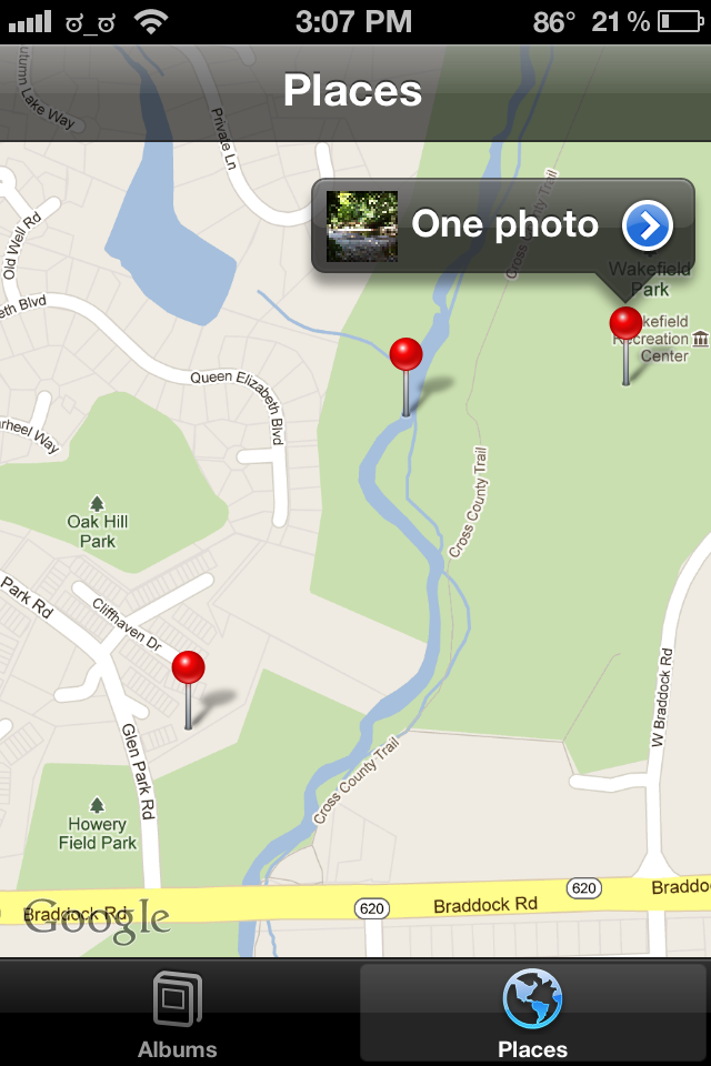
What's so unfortunate about this is that the gps data from this run was lost during the last transfer I did, so I wasn't able to use that to figure out where exactly I was. What IS lucky is that I took these photos with my camera, so I was at least able to use the GPS part of photostream to locate on a map, where each of these were taken:
 |
| This is where I took this first photo and it's where I was when I finally admitted to myself how lost I was. |
I had run five miles and was nowhere near where I started, so I was obviously not on this loop that I had planned on running. I found myself in this maze of mountain bike trails behind Wakefield Park. The trails didn't show up on the maps on my phone, so finding my way from there back to the trail that I had been on was very tricky. As I got more tired and disoriented, I somehow managed to convince myself that the trail I was looking for was just on the other side of this creek:
 |
| Now to find somewhere I can actually cross, while still keeping my feet dry... |
So once I crossed what turned out to be Accotink Creek, I found myself completely off the trail, just searching for a way to cross back.
  |
| SO lost! |
 |
| Finally I just used the map on my phone to point me towards a road and ended up stumbling out of the woods into a field behind this person's backyard, right near Braddock Rd |
 |
| Once I got back to Braddock Rd, I used the map on the phone again to find my way back to the park and back to my car. |
No comments:
Post a Comment